Sunday, June 17, 2012

Iron Pyrites-Rhodo to 2nd Lake: Take One

So today's goal was to follow a tentative route marked out on Google Earth from the Rhododendron Lake area to 2nd Lake via Healy and Panther lakes.  And when a road starts out like this, the omen's appear good: Gold Dust!


The proposed route avoids the usual route to Rhododendron Lake, instead it takes a road marked as 155F in the Backroad Map book.  And boy, does it look promising: newly graded, and like a veritable four lane highway.  Five minutes later it still looks good.  And all the branches look promising too.  Could this be it - the route to the promised-land without paying the Timberlands Nazi his $2?


Below is an overview of the start of the route to the Rhodo Lake area along 155F.  As you can see there are two parallel ways to access this area (155F and 155E - label not present on the map), with 2 joining trails (dotted lines) between them.  More about those little beauties later...


 So I travelled down 155F, continuing through the three way junction just north of the power lines and continued south. Initially the road was good for the most part, but pretty soon "road" needs to exchanged with single track trail, and then -look to the left - "the goat trail".

In fact, I should have read the omens...The bicycle was the first of many that I would see: boots, wheels and gloves from previous trail tacklers who had come a cropper...fallen over and not noticed that they had jettisoned stuff in the fall probably.


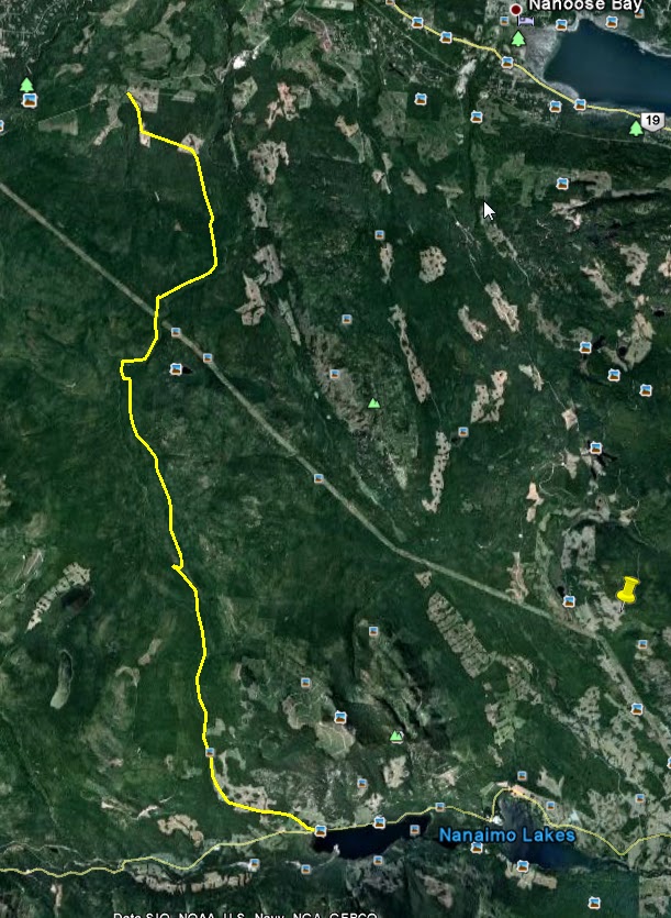
Here is my track superimposed in red on the northern proposed route (yellow)..


As you can see I tried every which way to get through. 


After the left turn to "goat trail" (which I traversed three times!) things got nasty.  First turning left at the end, I stopped and turned around as the trail was heading the wrong way.  Backtracking and going right, the trail was dark, rank and...foreboding.  The only respite was a short section crossing the power lines, where, if you look east, you can see them crossing near Rhodo Lake.  Be, warned, once you cross this opening, it back to Murkwood and evil that lurks there...


Murkwood: mossy covered rocks and slick logs, ruts, mud, thick, thick bush, trees down and hanging across the trail requiring manhandling...and noises... 


It was all first gear and clutch stuff and took me the best part of 45 minutes to get to the river. Alas, there was no bridge.  These shots are off the easiest sections - I just didn't have the places to stop or the fortitude to reach for my camera button during the rest of it. And did I mention the bloody alder!


Don't go any further here.  There is a steep trail that leads down to a gorgeous river, but alas, the bridge is long gone, and even though the BRMP indicates a crossing, I couldn't see any signs of any bridge.

 Bridge?..
 What bridge?

Evidence of someone else, creek side, who had endured the hardship only to be stopped by mother nature.  Cold soup though?
Resting, peeling off the layers and sitting on the "Mossy Knoll Bistro", I ate my kedgeree and pondered.  What now?  I could explore the rest of 155N later, but I had noticed a trail, that looked fairly good, off to the right earlier that might take me, according to my GPS, to Moriarty.  It would mean double backing through that goat trail joiner trail and turning left and continuing on the better trail.  That damn nemesis again! 

So that's what I did.  The trail to Moriarty started well, and continued that way for some time, but eventually, once it started ascending, it began to be comprised of thick trees either side, with alder growing up the middle and two old tracks which were rutted and nasty.  But hope springs eternal, and cresting a rise, the trail began to look easy again, until...

The log looks easy, but it's impossible to work the bike through, and I was running out of energy for more wheelies...
So, once again, I turned around.  The going got pretty rough; in fact, by the end of the multi-hour ride, and exploring many trails and traverses, I was incredibly fed up with ducking undergrowth, riding over logs, foot thick mud and alder. The bloody alder!  It was everywhere, and safe to say that since many of these trails have been recorded in the BRMB, things have changed. 

However, this last trail was the most promising, and looking at GE appears to crest with some lovely views and get to Moriarty Lake...  Mind you, I make no promises, "appears to" is, as I have found today, very different from "does"...


This "trail" is clearly marked as a major trail on the BRMB; however, it's long dead...

This trail had me off, twice in the same spot coming and going!   It is the second (most east) joining trail between 155F and 155E, which I thought I'd try on the way back.  Big mistake!
Needless to say, all that glitters is not gold.  It was iron pyrites today...

Here are some vids of the day, nothing special just short terrain samplings...


A very technical and exhausting ride today, not least through the magic of iPhones I got an email in the middle of Murkwood, from a prospective buyer to say they wanted to see my bike today at 5pm! It was just after that I dropped it twice!  No damage done, but never ride on moss!  My foot still twinges.  Still a powerwash later and the man is motivated...

Still, I'll not give up on the connector: the route has to be there somewhere!

Paul


Sunday, June 10, 2012

Moriarty Lake: Elusive As Always...


After a couple of days of perusing Google Earth for the best route to Moriarty Lake (and possibly a back way into some interesting places...), I decided to give it a shot yesterday. 

But first, some fishing.  I dangled a hook via email and got a nibble: Andy took it hook, line and sinker, and he was enthusiastic about joining me on this ride.  This was going to be a long-shot, and I was perfectly fine with trying it myself, but it's always better to have company, particularly as I saw my first big bear of the season last week on a similar ride.

The route was to get to take 155N from the Englishman River main and from their to bear (excuse the pun) left and then right to follow the trail that parallels the creek to the lake. 


The road up 155N began fairly easily.  And to illustrate the point, a half ton truck, complete with canopy and canoe/boat mounted on top came down on the single track road.  Unfortunately, the driver looked rather grumpy at having to stop and let two bikers through, so I didn't stop to pick his brains on the local topography, trails and lake access...This was a decision I regretted later.  

As we headed up, there were several nice and easy looking trails off to the right that we passed on the way up.  However, when it came to taking the right turn we needed to take, we were greeted by what can only be described as a shambolic creek bed complete with ruts, river-rock pebbles on a bed of sand, and some fair sized boulders.  There was no way a four wheeled vehicle of any kind had been up here in years.  Last season, when I started-off road riding, I would have tackled this slowly, and a trail like this would have had me off in a trice; in fact, I have come a cropper two or three times on "trails" like this.  The trick for me, I have learned, is to use the bike's torque, slip it into second and feather with clutch, keeping my speed up and my weight on the pegs, picking my route but not worrying too much if I don't get the perfect line.  The bike's suspension will take care of any mistakes.  And so it was that we made good pace up this goat trail until I broke my own rule and slowed down at the sight of a large slab-like boulder in my path.  This was a poor decision, as we were now on some serious grade, and all my rear wheel wanted to do was kick some large round river rocks out of the way and dig itself a grave.  So that was it. Neither Andy or I could get our bikes to get going again.  It was very disappointing, but one-wheel drive is one wheel drive!

What was really galling was that the truck had a boat attached - and the only real lake of any note in the area is Moriarty: so how did he get there?  I think I have the answer, but more on that later...

Aborting this trail and heading down, we tried an alternative route, which, despite all evidence being contrary from our GPS's, we thought might get us to the lake.  As it turned out, it didn't, because of snow!  Also, I don't think the trail actually goes far enough.  However, the ridge line views of Mount Moriarty and Mount Arrowsmith were spectacular, and my puny little helmet-cam doesn't do it justice.

 
 Above: the world really is round! ;-).  Looking twoards Mt. Moriarty; the lake is hidden behind a ridge to the left...Elusive!  We're at about 3100ft or 1000m here.  Below: Mt. Arrowsmith to the left, and the valley continues up towards Qualicum or so...

Below: ostensibly it was the snow that halted our progress for the second time in as many minutes.  I tried to dig a trail through it, but the ever dour Scot-cum-Welsh-nay-saying-hobbit, impersonating Andy on this trip, was the real impediment to progress and took unflattering photos of me while besmirching my ancestors...as I toiled, fruitlessly, alone.


As you can see the road surface here is fabulous and we could have carried on for miles, if it hadn't been for the white stuff...

So turning back for the second time, we decided to head to Marshall Lake, a trip I had done a week or so ago - as every ride must have a reward at the end of it!  Below, a panoramic of Marshal from a vid that Andy took.  We saw a large bear on the way down, about a click or two nearer the lake than I saw my last (the same) bear last week.  He or she was a large healthy specimen with a good sense of self preservation tinged with a hint of curiousity.  Very cool!


Below: here is a GE overview of the key trails for the day: "Thwarted" indicates the location of the inclined gulch-goat trail that finally stopped us enroute to Moriarty Lake.


Below: some detail of the aborted Moriarty Lake attempt with a possible work around...Is this the route the truck took (blue question marks; continued original route in yellow)?  The alternate turn-off starts at one of those "nice and easy looking" right turns I mentioned earlier...Hmmm?  Perhaps more sleuthing is needed, my dear Watson!


Above: Click for larger image...

I believe Andy's vid shows this alternative possibility also:


Why didn't we take it?  Your guess is as good as mine - rareified air, perhaps :-)

I'm not quite sure what "Bride Closed No Access" means.

So Moriarty skunked us this time...for now.

Paul