Since my last post on the B25 wreck back in January a few kind souls have come out of the woodwork to offer some more information on the potential location of the Mitchell's final resting place. Firstly I was sent archive photos of the wreck site on Mt. Whymper back in early February, and, yesterday, I had contact (via the blog) with a second individual who has got very close to the wreck site and offers a slightly different location than the old coordinates suggest. It's all very intriguing. But first the photographs (click to enlarge)...
 |
| Copies of National Archive photos which were sent to me from Michael Taylor. These are shots of the wreck's location on Mount Whymper. While forest cover over the terrain will have no doubt changed in the 70 odd years since the crash, the deeply contoured walls of this box canyon like valley will no doubt still be visible. The quality is poor, and consequently any attempt to match them with GE is pure guesswork... |
By scouring Mt. Whymper with Google Earth, it is possible to find several locations which may, or may not be (!), the likely location for the wreck. But one intriguing match is nearer the peak itself...
 |
| There are lots of potential look-a-likes around Mt. Whymper and scouting out using Google Earth can be frustrating...But this one does look familiar...no? However, looking north west as it does, it contradicts some evidence below... |
Other pictures from Michael, all of which suggest some sort of elevated valley with a shear terminus - and again, those strong almost vertical contours suggesting falls and snow-melt canyons...:

 |
| Above: If the notations on this phototraph are to be believed regarding Mt Landale and El Capitan peaking above the Whymper ridgeline, then this photo was taken from north of Whymper looking south...which opens up a whole new can of worms... |
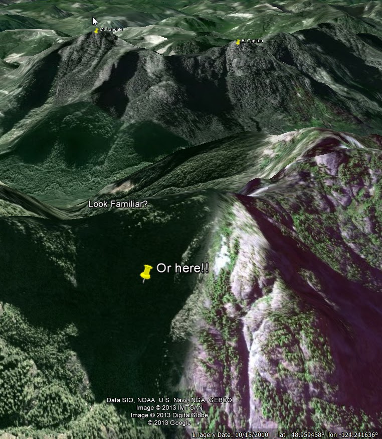 |
| It's hard to see any detail in this north facing elevated valley, but if the notations on the pictures above are to be believed, then this could be the rough location of the wreck site...As I said, frustrating (but intriguing too). |

Today, I got the following updates from a reader, Lindsay Elms, which is very helpful and offer a potential insight into a more exact location based on the fated rescue mission by the blimp:
The crash site is at the 840m level NE of where you have the arrow...I went to the Blimp crash site a week ago which is a couple of hundred metres
from the bomber. AT the time we didn't have the exact details of the bomber (and
couldn't see it). I hope to go in soon (we have special permission from the
timber co to go in via Jump Lake.)Both the Blimp and Bomber sites are historical
war graves even though there were no dead at the blimp crash.
Lindsay Elms
www.beyondnootka.com
Lindsay Elms
www.beyondnootka.com
If Lindsay is right, then there are a couple of likely sites...Click to enlarge:
 |
| Both of these sites work for two reasons: one: Lindsay's elevation matches the photos, and, two, the southwestern facing elevated valley is steep and would indeed show views of El Capitan and Mt Landale above the Whymper ridgeline... |
Well, there you have it folks. If you are reading this and you have more info that I can use to update this so the Lindsay's, Michaels and the rest of us can find this crash site, then please share it. Lindsay, Michael keep in touch and (here's where I grovel), I know two guys who'd love the chance to tag along via the Jump Lake watershed area if given half a chance...No pressure ;)