As a member of the BC public, be alarmed. As a camper, hiker, fisher, off-road rider, quadder, or outdoor enthusiast, be VERY alarmed.
This isn't hyperbole; it IS JUST what it says on the tin. Ben Parfitt of the Canadian Centre for Policy Alternatives has just written an article in The Province that details the BC Liberal Party's plans to give the provincial cabinet powers to grant forest compatines de facto private control over public forests without first having to consult with or even notify the public.
Don't think this can happen? Well it already has on Vancouver Island. The forest companies have been given much of the Crown Land in the south and central island. It's not crown land. Last summer in Nanaimo, the Nanaimo River Road gate was locked from May on. It is still locked. There is no access allowed to vast tracts of previously accessible land. It's so bad the Fisheries are no longer stocking lakes in the area as access is difficult for them and, besides, no one is allowed access to fish. So why stock the lakes?
Now the push is on for the rest of the island and province to follow suit.
And the BC Liberals are not wasting any time for the election; they are getting this done before May by "introducing a two paragraph bill granting it powers to fundamentally alter the course of forestry in B.C."
Parfitt's article goes on to describe how forest companies will no longer just enjoy the right to log set volumes of trees on public forestlands, but now they will gain dramatically expanded powers to log trees on defined areas of crown land that in effect become their own semi-private kingdoms. Not only that, stumpage fees would be minimal to the province, and once these Tree Farm Licenses are granted, the province cannot take back the land without paying huge compensation payouts to the companies.
Why are they doing this? Because there isn't enough timber on their own lands to log any more. Why? Well the government has faced mounting criticism over a forest health crisis due to decades of over-cutting and the pine beetle attack. Numerous saw mills face closure in many rural communities, but could that have anything to do with exporting raw logs to China, Japan and other markets do you suppose? Logging companies have failed to replant adequately on government land: that's not a rumour; it's fact, as reported early last year - this government has the worst record of enforcing it's own rules on the private logging companies. Why? Because many of the ministers and MLA's have a personal stake in logging.
This was tried by a government 25 years ago, but it was scuttled because of a public outcry. Now they're trying again: quietly. It may be a different party (BC Liberals rather than the SoCreds), but many of the people - and private owners who mean to benefit from this, remain the same individuals they always were.
Read the article and spread the word: NO! No for my access; no for my children's heritage; no for the environment, and no to undemocratic raping of the public purse for private corporate interest. NO.
Thursday, January 31, 2013
Sunday, January 27, 2013
Suzuki DR650 Valve Adjustment
I first adjusted the valves on DR Siouxsie at 15000km - 3000km after the recommended interval. (You can find pictures and details at the following page: http://drsuzistravels.blogspot.ca/2012/02/valves.html?m=1).
However, it being winter, riding is scarce and since 5000km has gone by, I thought I'd have a look at them again yesterday, and took a poke around. Considering it had been 5000km (the odometer is at 20000km now) they were in good shape. The exhaust valves needed readjusting as one in particular had tightened, so I set them both to 8 thousandths of an inch - right in the middle of the 7-9 thou range. The intake valves though were still as they were when I had set them - 4thousandths.
But the whole process took way too long as my feeler gauges were just too large for the small confined area. Trying to get them level and to FEEL the pressure needed to slide the gauges in was almost impossible, especially with the frame-obstructed forward facing exhaust valves. So I decided to hunt for some gauges that would allow me to FEEL... They had to be small, have a small angled gauge on the end of a rigid rod that could be manipulated easily. I have found some by a firm called Motion Pro and they are sold for $6 each in Canada. Each gauge has two ends and they come in the perfect sizes for the Suzi's intakes and exhaust valves: .004/.005 on one gauge and .006/.008 on the other gauge. The only problem is the Canadian Website that lists them is going to charge $20 for shipping. Come on, guys, they're feeler gauges not tires! So I will continue to look around the web for them. I have another 12,000km to go before I need to the job again. Plenty of time!
Here is the website: http://www.motosport.com/CA/dirtbike/MOTION-PRO-TAPPET-FEELER-GAUGES

Sunday, January 20, 2013
DR Gets New Chain and Sprockets

When I bought the 2007 DR two years ago, it was in great condition, but hadn't been ridden for a while. It was the local Suzi dealer's personal bike, but he never rode it, so it sat waiting for a new owner, sometimes outside...in the rain. I remarked that the chain was fairly rusty-looking in places, but was given assurances that the chain would recover after lubrication and use. Initially I heavily lubed it, and it functioned reasonably well; however, after two cleanings and re lubing it was evident that three links were jammed and the rest of the chain behaved like an arthritic snake. I rode it all last season despite that. It was particularly noticeable when the bike was wheeled around: it took more and more effort to move it, and when lubing the chain on the milk crate stand I use, the wheel would no longer spin freely, but stop almost immediately. Funny though, it didn't stretch very much over the two years. It did make a noise though, which was particularly noticeable when it was wheeled from one place to another - a sort of grinding with a triple click every revolution where the jammed links had to make it round the confined space of the counter-shaft sprocket...
Well all that's sorted now. I spent a few hours yesterday replacing all the sprockets, relubing the rear bearings, axle etc and shortening the new chain to 55 links, then installing it and using the snap link to shut it. Wow, what a difference. I haven't ridden it yet, but the back wheel spins like it never has. Can't wait for the dirt!
Tuesday, January 8, 2013
B25 UPDATE: 1944 Wreck Coldcase Comes Alive
After posting the previous blog post, and posting a request for information on this wreck on the club-tread forum for Vancouver Island, people came out of the woodwork to help me find more information on the B25 wreck on Mt. Whymper. I was put in contact with George Williams in Port Alberni and he sent me a package detailing the crash particulars including a more accurate location for the wreckage and a couple of maps showing it's likely location. Thanks, George! George has a website known as On Hole-y Ground Project "which aims to correct some of the [crash] records by going these sites, and fixing the exact position with GPS readings..." Check it out. Also, thanks to Marko and hilly from Club-Tread for their help and background on the search efforts, sources and descriptions of the wreck site.
Firstly, no one seems to have visited this site for eons, if ever. Some have tried, but snow always stopped progress.
There are various sources (the first one can be found in its entirety on Google Books) that discuss this wreck in passing, including details of the search party and the terrain (Thanks to Marko):
From the book Harbour City: Nanaimo in Transition:
The carrier pigeons were put to good use on May 26, 1944, when a RCAF crew of five crashed on 4,600-foot-high Mount Whymper, about 20 miles southwest of Nanaimo. Maffeo was in charge of the rescue party that included game wardens Frank Greenfield and Jim Dewar and RCMP officer Bert Lannock. They flew over the area in a Canso floatplane before finding clothing hanging in the trees near the top of the mountain. The plane had been fully loaded with bombs and had exploded on impact. Pieces of the plane and men were scattered over a half-mile radius. A ground crew of six men was dispatched from Jump Lake on May 29, along with four of Naylor's pigeons. It took until June 3 to reach the site. The birds carried the information back to Nanaimo.(P126)
The carrier pigeons were put to good use on May 26, 1944, when a RCAF crew of five crashed on 4,600-foot-high Mount Whymper, about 20 miles southwest of Nanaimo. Maffeo was in charge of the rescue party that included game wardens Frank Greenfield and Jim Dewar and RCMP officer Bert Lannock. They flew over the area in a Canso floatplane before finding clothing hanging in the trees near the top of the mountain. The plane had been fully loaded with bombs and had exploded on impact. Pieces of the plane and men were scattered over a half-mile radius. A ground crew of six men was dispatched from Jump Lake on May 29, along with four of Naylor's pigeons. It took until June 3 to reach the site. The birds carried the information back to Nanaimo.(P126)
From Never a time to trust: a story of British Columbia,
her pioneers, predators and problems
Mt. Whymper search party. Left to right; Jim Dewar, Pete Maffeo, Frank Greenfield, Bert Tannock, Lt. Cherry Lee and Cpl. Hails. This was the search party organized to locate the R.C. A.F. bomber that crashed on Mt. Whymper, spring 1944, five killed. Wreckage found, noon June 3, 1944. Horse taken part way to carry supplies. Plane and crew blown to smithereens and scattered for half a mile.
***************************************************************
And this from Hilly: One discussion board I searched had the coordinates at 48
58.5'N 12 411.5'W. If they are correct, it looks like it's about 2 km from the
summit on the ridge. I've seen the ridge from a few different angles and it
looks quite jagged and more of a climb than a hike.
Also, I've been skunked trying to climb Whymper at this time of the year because of snow on the logging road. It snows lots there and it is shaded so it takes ages to melt. It's a nice drive, but I think you will have trouble getting to the base of the mountain for a few months now.
If you do make an attempt post up what you find!
**************************************************************
Below: On to the B25 wreck. Firstly here is an updated GE overview of the new predicted position of the B25. It is located north of Youbou on a ridge running northwest of Mt Whymper at about 1300m. You can see Jump Lake in the very top left of the picture.

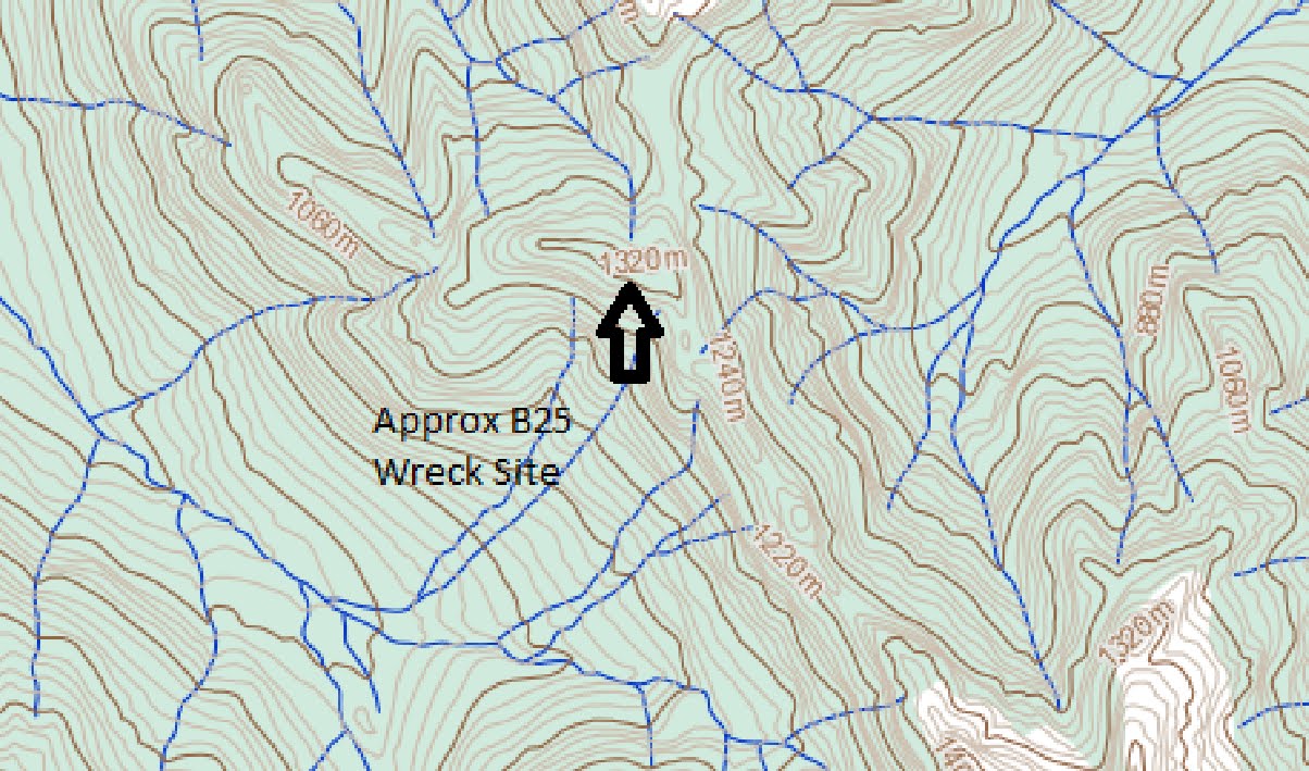
Below is an overview of the area between Mt Whymper and El Capitan Mountain with the approxomate wreck site located at 49.58.5N 124.11.5W (Degrees Decimal Minutes) For those of you like me who like decimal degrees, look further down...These images are taken from the publicly available maps (online!) from the BC Gvt: this one is map 92/C16 for reference.

Below: GE View of the above map image with the Whymper Ridge clearly visible.

Below: Closer...Whymper Peak is south east of the wreck...
And Below, the same approxomate view in GE

Below: A closeup of the wreck site. There do appear to be some rudimentary trails up and around there. But any sortie will likely be by foot once the bikes can't go any higher...oh for a KTM FreeRider...

Below: A potential trail with Decimal Degrees lat-long grid reference overlay.The Decimal Degree coordinates are, as best as I can convert: 48.975040N -124.191658W

Below: Overview from VIMB of Chemainus River Road which can be taken from north via the Jump Lake end, if you have a key, or, if you don't, from the east, Highway 1, via Copper Canyon Main, which branches into the Chemainus River Road.

Below: a close up of some trails that branch north just after the gate...these take you very close to the wreck's supposed location at the end of the river spur...which appears below...The last bit will be a hike...

More details to follow as they come in...
Subscribe to:
Posts (Atom)