Sunday, May 26, 2013

There And Back Again - Views of Cameron Main from 3800ft

Click here for a larger version of the animated trail...

EveryTrail
Today's ride with Andy: supberb trails and stunning views...later

We set off late into what we knew would be torrential rain.  While the coast was bathed in sunshine, the interior mountains were obscured with dark gray behemoths.  It rained from the Englishman River bridge on, but that didn't dampen our spirit, even if it did soak us to the skin for four hours or so.  My heated vest was a real bonus, but forgetting my waterproof pants was a bonehead move.
 
As usual we were just exploring, with the outside hope that we might find a away through to the Cameron Main, Labour Day Lake, Mt. Arrowsmith, and perhaps even a route north to Port Alberni.  First we snuck up the beginning of the key trail to see what the logging co had been doing up there.  They have widened and flattened the road nicely for the first quarter of the trail - thanks, guys!   Then we got back to 155 and headed West again and past the Englishman River bridge.  We've never explored here: what a bonus.  We found some excellent riding terrain - really awesome and this ride is highly recommended for anyone who likes views (check the weather first!), grades and torque...Here's the route overview.


Above (Click for larger view): We turned onto the 155N for quick look see and to check out the state of the key trail since the winter logging.  It's great - a cat has leveled and widened the first 1/3rd of the trail.  Unfortunately they've also levelled most of the trees.  Clearcut?  Where?  Below: the key-trail looks completely different...With the Clarkian Liberals in power for the next 4 years, you can expect the capitalist-consumer driven rape and pillage to be the Status Quo...


 Below (Click for larger view): Carry on past the Englishman River bridge (that is don't cross it).  A few km after this the trail starts to get rewarding...

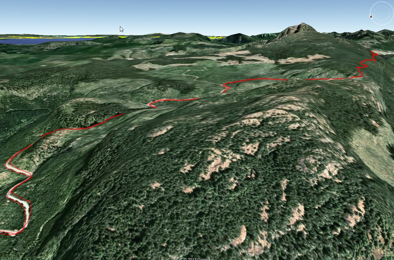
 Below (Click for larger view): Looking west towards Mount Moriarti.  This is where the trail gets fun and you climb to the alpine plateau.  The trees become smaller.  The road surface is excellent and hairpins and steep grades, even wet, make for some supberb riding.  It was socked in, and I can only imagine what the views must be like when it's clear.  Waterfalls tumble from great heights aplenty, but watch for deer - they're everywhere here often darting out.  Unlike our residential semi domestic rose-eaters, these are extremely skittish and large...  We did not explore many side roads, of which there are tons...

 Below (Click for larger view): Once up on the plateau, you will be heading east towards Moriarti - which you can see in the distance.  Look to your right - you are looking down a few thousand feet at Cameron Main.  Again there are a few side roads to explore here.  We have left them for later...and better weather
 

 Below (Click for larger view): We were stopped by snow in several places and the new road finally terminates not far from the old Cameron Main Ridge trail.  Given a few more months, we can only hope the two join...perhaps wishful thinking...


 Below (Click for larger view): As you can see the roads are in good shape, albeit a bit wet on the day.  The mountain peeking through to the south is on the other side of the Cameron Main.

 Below (Click for larger view): the road split to a Y, with the upper road going on for much further.  Unfortunately, due to the elevation (3800ft) it is still choked with snow. 
 
 Below (Click for larger view): We didn't take any pictures while we were passing through the plateau, which was a pity as it was very picturesque...however once through, this is what we found. 


All in all, another good day riding.  A stop at the Black Bear afterwards for a London Pride and some chips helped get us home.  It was a hot bath for me to chase off the mild hypothermia from being soaked for a few hours.  It didn't rain a drop in Nanaimo, but be warned, the interior highlands are completely different.  I haven't ridden in rain like that for years....  Great fun though.  We'll be back.

Sunday, May 5, 2013

Englishman River to Cameron Lake?


With 25C forecast for all this week, come Saturday mid-day I was itching for a ride.  After adjusting his chain, Andy met me at the track and we headed out along 142 and 155 to the Englishman River bridge and into the Cameron Land District with the hope of finding a route into the Mount Arrowsmith Regional Park, or - less likely - right through to Highway 4 just east of Cameron Lake.  Having tried from the other end via the number 4 from the north a year previous and being skunked while heading south near Lockwood Creek by an overgrown singletrack trail obliterated with gulches and ditches, we were curious as to whether the fairly recent logging road activity in the headwaters of French Creek would allow us to head north and connect. 
 
Click the image for a larger view: Our attempt from the north a year previous in red.  The yellow is a possilbe connector still choked with snow.  The red in the south is the limit of our northern penetration into the Cameron Land District.
There was little or no traffic all the way there, and riding in just a tee-shirt and armour mesh it was perfect.  As we crossed the bridge we settled on ascending to an alpine lake (3300ft) to see if it was snow free and fishable, and then to head on towards the previously washed out box canyon turn and cross the headwaters of the Englishman River. 
 
A reservior-lake.  Apparently guarded by cameras at the top of the steep windy road up.  I'm told carrying zap straps and decorating the rear of your vehicle with a seasonal sprig of conifer, fern or holly is the necessary tip of the hat to the Gods that inhabit this spiritual lake (and it also ensures anonimity and reduces flash refection off rectangular aluminum plates).
 
It's a deep lake, with no action right now, probably due to the snow still lining the steeply shaded northern shore.  Mount Arrowsmith is peaking (excuse the pun) out on the top right...
 
The rest of the journey was purely exploratory and we rode up the other side of the Englishman River valley after crossing it's headwaters.  There are some great views right down the valley, but seeing as I've blogged those before, I'll not repeat them here. 
 
Click to enlarge: after the lake, it was up into the Cameron Land District...
 
Pretty soon we crested the hills and began to explore the newly minted roads up there.  The first one, despite being short, windy, steep and ending without a view, was amazing, because the view of Mount Arrowsmith on the way down, previously missed, was epic.  Dresden corner was the epithet we gave to the best viewpoint of the mountain.  Don't ask why, we'll not tell...
 
Above - Click to Enlarge: Crack a beverage, open some jerky and look west from Dresden Corner...


Andy reaching for his camera.  But the little iPhone/garmin gps cameras don't do it justice.  Get there, you'll know what I mean.

 
After that it was trying to find any trail that went north and to Highway 4...No luck, but not because it doesn't exist, but because of snow.  There are plenty of trails here left to explore... I'll leave you with some maps, and a few more pics.
 
Above: Click to enlarge: here we were stopped by snow.  The trails were single track and heavily shrubbed on either side, but a quad or a dirt bike will have no trouble.  There were several trails off of them thad we didn't take...future considerations.  Great views.
 

Above - click to enlarge: the Highway 4 connector looked promising.  Large, although rough, it was still largely snow covered, and not suitable for one wheel drive yet...
 
Odds and Sods...