Saturday, March 30, 2013

Okay Not Okay...Reworking Rhodo

Andy and I had a quick blast today to see if we could summit Okay Mountain on the bikes. While snow was not an issue (unlike last year at this time), boulders on a sharp incline were, and we bailed, although we made it a little further than before. Then it was off to Rhodo for some fishing, but, alas, we were sidetracked by old roads being re-engineered, ready for more logging. It seems the Okay mountain area is being hit on all sides...


Tuesday, March 26, 2013

Circumnavigating Okay Lake


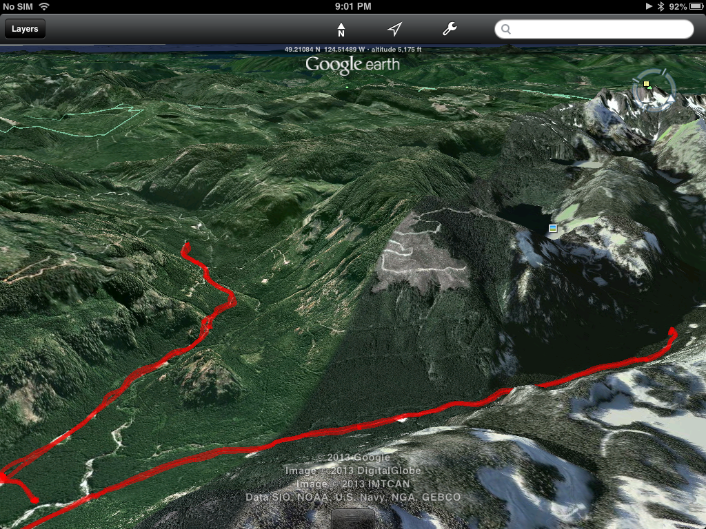
Having ridden to work this morning, I decided to go for a quick blast to locate a new feature recently exposed by the extensive logging that Timberlands are doing around Okay Lake right now. It's been a while since I've been to Okay Lake (a year or so) and ridden the trails around it, so, naturally, I got a little lost at first. However, given the plethora of new logging access roads since last year, and the extensive "terra-forming" the logging co has done, it's not surprising. Many of the features and the visual cues that I have used to identify the correct trail to circumnavigate the lake using the Okay mountain road are...well, gone. I actually ended up at the lake before I'd realised I'd missed the left turn, as the entire first part of the trail is completely different.


Above: I rode in from the Boomerang - 142 junction and continued west towards the lake, completely missing the left (south) turn which takes you around the lake.  Below: the same shot, but from a northerly perspective.
 
Getting to Okay Lake, this is what I found...Much of the landscape has changed, with a paltry 3 or 4 tree-fringe around the east side of the lake.  The ride was great though with plush dirt and some mixed blast crush.  I'm sure enjoying that new front end on Siouxsie.
 
Above: There are several (7 or so) yarders and feller-bunchers dotted around this area, and on up the eastern slopes of Okay Mountain too right up to the snow line...
On turning west onto the new spur being constructed and following the contour of Okay Mt south, you come across more yarders.  Finally the goal of today's ride...A lone cabin, recently exposed by the logging.  You have to hike up a fairly steep incline for a short way to get the cabin.  This shot is from half way up the devastation...
 
 
 Below: Okay Lake shines like a jewel below from the same place the shot above was taken from.

The cabin was obviously once perched on a bluff surrounded on three sides by trees.  Unfortunately, none were left standing.  I suppose without legislation, the same would be true at Okay Lake below...


 The OK Corral cabin is rustic, but well constructed.  Whomever the owners are, they have created a great cabin.  I'm sure they'll be a little ticked when they seen their hidden gem is now exposed. 

 The view from the veranda is spectacular with Mt. Benson, Blackjack Ridge and Decosmos prominent, not mention the Strait and the mainland.  What a place to watch the sun rise with a warm coffee in your hand...Oh yes, there's a woodstove.

 Inside, it's well appointed.
 There's a guest book with frequent requests for interlopers to keep the place clean and to clean up after them. 
 The guest book has entries from at least 2008, and it makes for some interesting reading...including a run in with a cougar...

 
As it was getting late, I had to head.  I left everything just as I found it and hope that anyone who uses this does the same, including packing your own stuff out.  Judging by the notes left in the guest book, half the interlopers are respectful and value the generosity of the owners, and half are using it as a place to get blinded and behave badly. 
 
I found a new way back.  There is a new road called "Connector" which runs into "Hookup" which takes you close and north side of the lake hooking up eventually with 142 at the Boomerang Junction again.  There are many new roads in that section of Northwest Bay now, and more scouting to be done...


Saturday, March 23, 2013

Said the Bishop to the Actress: Just a Quickie

Andy and myself tried for Lucid Lake today, only to be stopped by heavy snow on a trail that had been ploughed...which in itself is interesting...So we explored some of the new roads Island Timberlands are blasting in right now around the hydro-lines. We will be trying to get to Mt DeCosmos from the hydro lines in a while, so I have included some pics on the maps..


Thursday, March 21, 2013

Rowbottham, Arrowsmith and ...?

We rode a 140 km today.  It was a cool, but well worth it, despite getting snowed on at elevation and being stopped at 2400 feet on all three trails we tried today.  Briefly, this is the route:

Above: we rode from Dumont to 155 via Boomerang and the hydro lines.  Timberwest crews were out in force today in the Okay Lake area, which we briefly tried to get to, and also blasting a new road parallel to the hydrolines on the southeast side of Okay mountain.  Once at 155 it was straight down to the Englishman River bridge and right and up towards Rowottham Lake.
Above: the three routes we tried today from the ERBridge opened up lots of possibilities for future exploration.  This is an area we have only visited rarely. 
The climb towards Rowbottham lake was aborted at about 2400 feet by snow and the footprints of solitary predator tracks shadowing an elk or two...the views up there were stunning, with the weather rapidly changing every few minutes..
Above: the other two routes.  We nearly made it to the Arrowsmith Lake entrance (you can see teh reservoir-lake perched tarn-like some thousand feet above the route), past the 28km sign, but we were stopped by snow.  Riding back to the bridge, we explored 155 a few km to the right (south-south-west), and again, climbing, were eventually turned back by snow.  This is an interesting route with many side trails worth exploring too.  This could well offer a route to the Cameron Valley Main and the other side...

Here are some pics of the route:
Above: Saw this Turkey Vulture picking over some bones of a medium sized mammal (winter kill?).  He got a little spooked by our close attentions.  Luckily it turned out not to be an oman for our ride...

Below, en-route to Rowbottham (east along the other side of the Englishman R), a recent windfall blocked the road.  A large boulder enabled us to roll and crack it...


Above: the view from the Rowbottham Lake road back towards 155 and south-west to Arrowsmith.

Below:, twas chilly at 2400ft...


A great ride, with more questions than answers...Just the way we like it...

Monday, March 18, 2013

Siouxsie Comes Out of Hibernation...


Siouxsie got out for her first ride today.  Forking over $476 for 8 months insurance was hard to swallow, but today's ride put it all into perspective.  It was a relatively warm day today, and, together with Andy, we put nearly 100km on the clocks and blew the cobwebs off the bikes.  I didn't have too much hope for getting very far or high, as last year's first ride (April 4th - in honour of Martin Luther King) ended up stopped short by snow.  But how wrong I was...

The overall route looked like this, starting from Dumont and heading southeast at first, only to be turned back by active logging.  So we settled for a run up to Sundew Main - where Mourning Cloak butterflies were all over the road sunning themselves.  I had no idea butterflies were about this early in the season. 
We found a couple of lakes on the way back, but they are far too choked by deadfall and ex-trees to be fishable...We rode up a couple of old spurs which were good fun.  You can see the lake/ponds below...
But more fun was had after 4pm, when the crew had knocked off and we made it up to Blackjack Ridge for an overview of our riding area...
Wow.  The views were stunning and you can see as far south as Mount Whymper (where there is a plane wreck we'd like to uncover), West to Mts Arrowsmith and Moriarti (on our plans too for this year) and north east to the main land...


We snapped a few shots on from the ride:
The larger of the two choked lakes...Old man's beard growing on the bark of a dead tree - a testament to the air quality here on the west coast.  This stuff doesn't grow in urbanized or polluted areas...

Above and Below...Green Mountain -an ex ski hill -from BlackJack Ridge...You can see second lake below the mountain...Mount Whymper - the highest Island peak south of the 49th - lies in the distance, just about where that little fir tree is pointing.

Below: The hydro-line trail that we frequently take to Rhododendron Lake... You can see it turn north east in the distance.  The lake lies on the other side of those hills.

 
Below: Mt De Cosmos...another goal for the future.  We're trying to find a way to the myriad of trails that go up it from the hydro lines, but so far, no joy....

Below: we didn't see too much of this stuff, and only in shady northern exposures unlike last year!  This is at over 2000ft.

And finally a 180 degree panoramic from Mt Whymper 15 miles south-west-south, Mt Hooker, Green Mtn, Mt Decosmos, Moriarti and Mt Arrowsmith to the Strait...


Thanks for the ride, Andy.