Saturday, July 6, 2013

De Cosmos, De Crash, and De Lesson


After scouting a route up to Mount Decosmos a few weeks ago, I managed to winkle the hermit out of his lair and entice him to give it a go with me.  I actual fact, Andy's bike looked much dirtier than mine as he has only had the time to ride small jaunts lately; whereas, mine, which hadn't been out for two or three weeks, was embarrassingly shiny.  But it's summer now, and with a few weeks holidays, it's time to explore.  We took the usual route via Boomerang and Cottle to the hydro-lines trail (which is still locked and gated about halfway between Blackjack and Rhodo).  Then we turned down towards the headwaters of Nanaimo River and came to the creek crossing.  We didn't bother clearing the creek out, although that would have been a better option, and just chugged across it.  I say chugged, really we splashed, thrashed and bashed our way across.  It wasn't too difficult and within a few seconds we were on the other side and staring down the "four lane highway".  And that's just what it is - smooth, well groomed and easy riding - amazing.  Whilst traversing the road which was desolate except for a few heaps of bear scat, I started wondering how this road could be in such good nick for an isolated road?  Pretty soon, and after passing a few interesting looking left turns towards Blackjack ridge, we passed a derelict hauling truck parked in what must have been the quarry for the road surface. 

(Above and Below) I'm not sure what vintage this KW is, but it's not as derelict as we thought.  It looks like it's dropped its differential oil while reversing and just been left.  It's obviously had a hard life, but all of its tyres are still inflated except for one.  Thankfully no one has vandalized it and it makes a great look see.


No more than 100m past the truck is a bridge with a sharp right turn.  Take it and climb to the next four lane highway.  Turn right (turning left brings you to a locked gate and first lake).  Pretty soon you come to some "Cutting Permit" signs.  Take the left fork and climb.  The switchbacks you will encounter are not bad at all, except for one steep rock strewn one.  We picked our way through this fairly quickly though - it's bark is worse than it's bite.  Soon you get to some great vistas:
Looking north-west OK mountain and the hydrolines running towards rhodo lake.  At this point you can see lots of the routes we regularly ride.

(Above)Looking north east back to Cottle, Boomerang and Blackjack Ridge you can see many of the trails we use.

Unfortunately after battling half a km of this stuff, it really is the beginning of the end for penetration up the mountain.  It's amazing how quickly these saplings grow: even quads will find this tough going...perhaps time for a work party?
Deciding that the smell of burning alder leaves on our engines, saplings playing with clutch and brake leavers, and the constant whack of branches in the kisser were too much, we turned around to explore a few other more open looking trails.  And they were peachy, so peachy, that yours-truly (not leading for the first time this ride) was too busy looking at the vistas and ran smack into the back of a stationary Andy...  What a clot! It was completely my fault. Man that's embarrassing to admit, but I'd better get it out there as a sage lesson to myself and any other idiot out there that doesn't look where they are going religiously!  Luckily we weren't doing maniac speeds and got off with a few bent indicators, levers and a nasty knee in my case.  Thank god for armour (wear it, folks - it's the first time I've needed it and boy did it work, all except one knee guard which took the first impact but not the next, and I now find myself writing this with an icepack on a large swollen knee, but, fingers crossed, no break - I hope...).  Poor old Andy's KLX took a knock - as did he - and some spare parts should get the bike legal again very soon...It could have been much worse: but for the sensible clothing we were wearing we could still be up there being nibbled by bears and bearing blow fly larvae...Nice thought.  Still, we got back down no trouble and skedaddled via first lake home. 

Still, it was a great ride, and am determined to ride it again and walk to the peak next time - making sure we start earlier and I watch where I'm going!


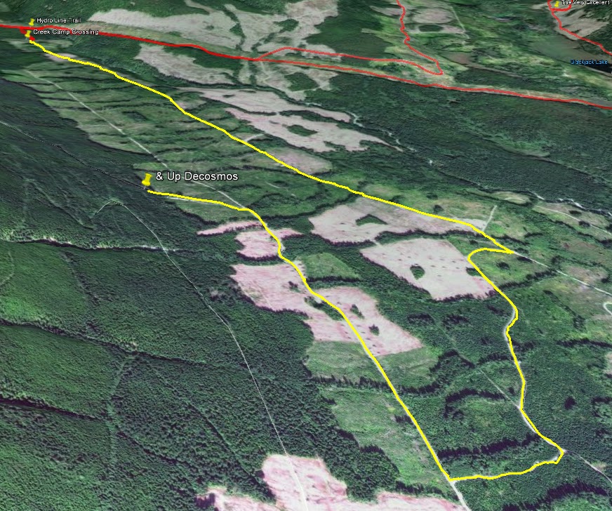
Here are the maps:
Above - a northerly overview of the route; Below a southerly perspective.


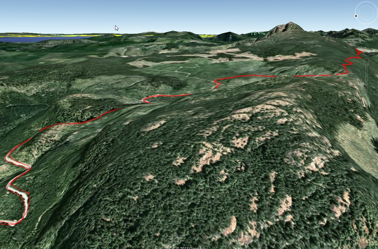
Above and below: a couple of peak shots showing the extent of our penetration into the alder and...embarrassingly the location of my blunder up Andy's chuff...

Thursday, June 20, 2013

B25 Update#2: Update Me and I'll Update You...

Since my last post on the B25  wreck back in January a few kind souls have come out of the woodwork to offer some more information on the potential location of the Mitchell's final resting place.   Firstly I was sent archive photos of the wreck site on Mt. Whymper back in early February, and, yesterday, I had contact (via the blog) with a second individual who has got very close to the wreck site and offers a slightly different location than the old coordinates suggest.  It's all very intriguing.  But first the photographs (click to enlarge)...
 
Copies of National Archive photos which were sent to me from Michael Taylor.  These are shots of the wreck's location on Mount Whymper.  While forest cover over the terrain will have no doubt changed in the 70 odd years since the crash, the deeply contoured walls of this box canyon like valley will no doubt still be visible.  The quality is poor, and consequently any attempt to match them with GE is pure guesswork...

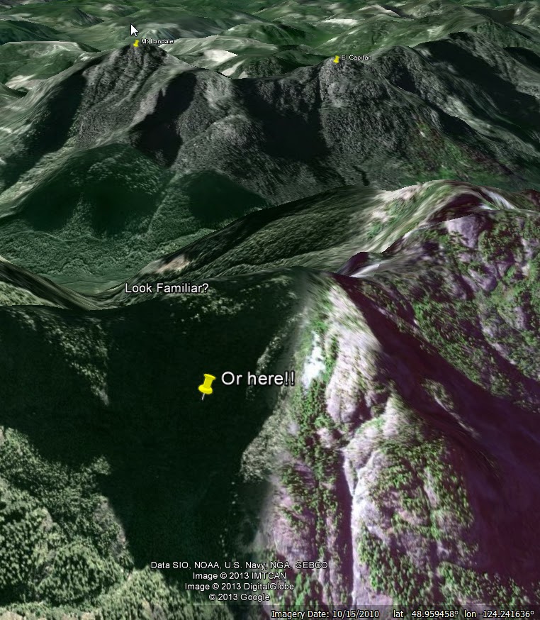
 By scouring Mt. Whymper with Google Earth, it is possible to find several locations which may, or may not be (!), the likely location for the wreck.  But one intriguing match is nearer the peak itself...
There are lots of potential look-a-likes around Mt. Whymper and scouting out using Google Earth can be frustrating...But this one does look familiar...no?  However, looking north west as it does, it contradicts some evidence below...
 
Other pictures from Michael, all of which suggest some sort of elevated valley with a shear terminus - and again, those strong almost vertical contours suggesting falls and snow-melt canyons...:
 
 
Above: If the notations on this phototraph are to be believed regarding Mt Landale and El Capitan peaking above the Whymper ridgeline, then this photo was taken from north of Whymper looking south...which opens up a whole new can of worms... 
 
It's hard to see any detail in this north facing elevated valley, but if the notations on the pictures above are to be believed, then this could be the rough location of the wreck site...As I said, frustrating (but intriguing too).


Today, I got the following updates from a reader, Lindsay Elms, which is very helpful and offer a potential insight into a more exact location based on the fated rescue mission by the blimp:
 
The crash site is at the 840m level NE of where you have the arrow...I went to the Blimp crash site a week ago which is a couple of hundred metres from the bomber. AT the time we didn't have the exact details of the bomber (and couldn't see it). I hope to go in soon (we have special permission from the timber co to go in via Jump Lake.)Both the Blimp and Bomber sites are historical war graves even though there were no dead at the blimp crash.
Lindsay Elms
www.beyondnootka.com

 
If Lindsay is right, then there are a couple of likely sites...Click to enlarge:
Both of these sites work for two reasons: one: Lindsay's elevation matches the photos, and, two, the southwestern facing elevated valley is steep and would indeed show views of El Capitan and Mt Landale above the Whymper ridgeline...
 
 
Well, there you have it folks.  If you are reading this and you have more info that I can use to update this so the Lindsay's, Michaels and the rest of us can find this crash site, then please share it.  Lindsay, Michael keep in touch and (here's where I grovel), I know two guys who'd love the chance to tag along via the Jump Lake watershed area if given half a chance...No pressure ;)

Sunday, June 16, 2013

Andy's Vicarious Ride

Well, as some of you know, The Real Motorcycle Diaries have dried up for the past six months or so.  Andy is very busy right now, so I decided to have a ride for him, visit some of his old haunts and then to post them.  I know, generous, but what can I say: that's the sort of guy I am...
Initially, I was going to fish for Andy, catch some trout and eat them for him, but, alas I ran into a snag halfway there. 

Above and Below: The gate was on a bridge: I have never noticed this gate before.  The two locks are not the usual Logging Co type, and I expect they are BC Hydro installed?  Anyway, there is no way through to Rhodo from Boomerang via the hydro line trail now, boys.  142, 155 and left is now the only way.  The gate is surprisingly low and you can see that quadders have had no luck getting through, though someone on a small dirtbike would be able to drag one under if they were so inclined.  Not me folks.


 So it was necessary to turn around and scrap that plan. Poor old, Andy, no fish! (Yes there is THE other way, but, well it was getting late...)  What do do?  Well creativity is my middle name (or is it torture? - I can't remember, which is another thing I love about getting older), so I decided to go to some of Andy's favourite haunts and remind him of some plans we have, some of the views he is missing, and just generally rub his nose in it  tempt him out again next weekend on a real ride.
Then I remembered one of Andy's goals: summiting Mount Decosmos.  He has a picture of a potential creek crossing route.  So why not find that and check it out?  Backtracking along the Hydro trail I found the clearly defined single track trail heading south.  It led to this.

Above and Below: Hmm.  I remember quibbling with him about this from one of his pics, saying I felt we could cross this.  Erm No.  Too bad because there is a veritable four-lane logging road highway on the other side which takes the rider to, yes, you guessed it, De Cosmos.  Ahh, but what's that on the right?


Just off to the right is a newly minted quad trail.  It's not too bad as described in my vid below...
The road on the other side...
Above and Below: the four lane highway to Decosmos...
The creek crossing doesn't look too bad, but, being as I was alone, it was late, I didn't cross.  Two people for help, and it's a snitch.  So it was back to the hydro-line trail and off to one of Andy's favourite (and if truth be known -coveted) spur view point trails.  It's quiet little number off the Blackjack trail.


Above: Decosmos tempts the Vicarious Andy...Below: the Very Excellent Viewpoint, with some excellent sandy climbing trails for awesome fun too!  I'm only sorry I couldn't fling some playfully from by big fat rear tyre at Andy while rocketing up there. 


So there you have it.  Andy caught no fish, didn't get to DeCosmos, and didn't get my rear tyre sand fans in his face.  Well you can't have it all, folks.  Especially if you're stuck at home.  Hopefully see you soon, hermit boy :-)

Sunday, May 26, 2013

There And Back Again - Views of Cameron Main from 3800ft

Click here for a larger version of the animated trail...

EveryTrail
Today's ride with Andy: supberb trails and stunning views...later

We set off late into what we knew would be torrential rain.  While the coast was bathed in sunshine, the interior mountains were obscured with dark gray behemoths.  It rained from the Englishman River bridge on, but that didn't dampen our spirit, even if it did soak us to the skin for four hours or so.  My heated vest was a real bonus, but forgetting my waterproof pants was a bonehead move.
 
As usual we were just exploring, with the outside hope that we might find a away through to the Cameron Main, Labour Day Lake, Mt. Arrowsmith, and perhaps even a route north to Port Alberni.  First we snuck up the beginning of the key trail to see what the logging co had been doing up there.  They have widened and flattened the road nicely for the first quarter of the trail - thanks, guys!   Then we got back to 155 and headed West again and past the Englishman River bridge.  We've never explored here: what a bonus.  We found some excellent riding terrain - really awesome and this ride is highly recommended for anyone who likes views (check the weather first!), grades and torque...Here's the route overview.


Above (Click for larger view): We turned onto the 155N for quick look see and to check out the state of the key trail since the winter logging.  It's great - a cat has leveled and widened the first 1/3rd of the trail.  Unfortunately they've also levelled most of the trees.  Clearcut?  Where?  Below: the key-trail looks completely different...With the Clarkian Liberals in power for the next 4 years, you can expect the capitalist-consumer driven rape and pillage to be the Status Quo...


 Below (Click for larger view): Carry on past the Englishman River bridge (that is don't cross it).  A few km after this the trail starts to get rewarding...

 Below (Click for larger view): Looking west towards Mount Moriarti.  This is where the trail gets fun and you climb to the alpine plateau.  The trees become smaller.  The road surface is excellent and hairpins and steep grades, even wet, make for some supberb riding.  It was socked in, and I can only imagine what the views must be like when it's clear.  Waterfalls tumble from great heights aplenty, but watch for deer - they're everywhere here often darting out.  Unlike our residential semi domestic rose-eaters, these are extremely skittish and large...  We did not explore many side roads, of which there are tons...

 Below (Click for larger view): Once up on the plateau, you will be heading east towards Moriarti - which you can see in the distance.  Look to your right - you are looking down a few thousand feet at Cameron Main.  Again there are a few side roads to explore here.  We have left them for later...and better weather
 

 Below (Click for larger view): We were stopped by snow in several places and the new road finally terminates not far from the old Cameron Main Ridge trail.  Given a few more months, we can only hope the two join...perhaps wishful thinking...


 Below (Click for larger view): As you can see the roads are in good shape, albeit a bit wet on the day.  The mountain peeking through to the south is on the other side of the Cameron Main.

 Below (Click for larger view): the road split to a Y, with the upper road going on for much further.  Unfortunately, due to the elevation (3800ft) it is still choked with snow. 
 
 Below (Click for larger view): We didn't take any pictures while we were passing through the plateau, which was a pity as it was very picturesque...however once through, this is what we found. 


All in all, another good day riding.  A stop at the Black Bear afterwards for a London Pride and some chips helped get us home.  It was a hot bath for me to chase off the mild hypothermia from being soaked for a few hours.  It didn't rain a drop in Nanaimo, but be warned, the interior highlands are completely different.  I haven't ridden in rain like that for years....  Great fun though.  We'll be back.

Sunday, May 5, 2013

Englishman River to Cameron Lake?


With 25C forecast for all this week, come Saturday mid-day I was itching for a ride.  After adjusting his chain, Andy met me at the track and we headed out along 142 and 155 to the Englishman River bridge and into the Cameron Land District with the hope of finding a route into the Mount Arrowsmith Regional Park, or - less likely - right through to Highway 4 just east of Cameron Lake.  Having tried from the other end via the number 4 from the north a year previous and being skunked while heading south near Lockwood Creek by an overgrown singletrack trail obliterated with gulches and ditches, we were curious as to whether the fairly recent logging road activity in the headwaters of French Creek would allow us to head north and connect. 
 
Click the image for a larger view: Our attempt from the north a year previous in red.  The yellow is a possilbe connector still choked with snow.  The red in the south is the limit of our northern penetration into the Cameron Land District.
There was little or no traffic all the way there, and riding in just a tee-shirt and armour mesh it was perfect.  As we crossed the bridge we settled on ascending to an alpine lake (3300ft) to see if it was snow free and fishable, and then to head on towards the previously washed out box canyon turn and cross the headwaters of the Englishman River. 
 
A reservior-lake.  Apparently guarded by cameras at the top of the steep windy road up.  I'm told carrying zap straps and decorating the rear of your vehicle with a seasonal sprig of conifer, fern or holly is the necessary tip of the hat to the Gods that inhabit this spiritual lake (and it also ensures anonimity and reduces flash refection off rectangular aluminum plates).
 
It's a deep lake, with no action right now, probably due to the snow still lining the steeply shaded northern shore.  Mount Arrowsmith is peaking (excuse the pun) out on the top right...
 
The rest of the journey was purely exploratory and we rode up the other side of the Englishman River valley after crossing it's headwaters.  There are some great views right down the valley, but seeing as I've blogged those before, I'll not repeat them here. 
 
Click to enlarge: after the lake, it was up into the Cameron Land District...
 
Pretty soon we crested the hills and began to explore the newly minted roads up there.  The first one, despite being short, windy, steep and ending without a view, was amazing, because the view of Mount Arrowsmith on the way down, previously missed, was epic.  Dresden corner was the epithet we gave to the best viewpoint of the mountain.  Don't ask why, we'll not tell...
 
Above - Click to Enlarge: Crack a beverage, open some jerky and look west from Dresden Corner...


Andy reaching for his camera.  But the little iPhone/garmin gps cameras don't do it justice.  Get there, you'll know what I mean.

 
After that it was trying to find any trail that went north and to Highway 4...No luck, but not because it doesn't exist, but because of snow.  There are plenty of trails here left to explore... I'll leave you with some maps, and a few more pics.
 
Above: Click to enlarge: here we were stopped by snow.  The trails were single track and heavily shrubbed on either side, but a quad or a dirt bike will have no trouble.  There were several trails off of them thad we didn't take...future considerations.  Great views.
 

Above - click to enlarge: the Highway 4 connector looked promising.  Large, although rough, it was still largely snow covered, and not suitable for one wheel drive yet...
 
Odds and Sods...


Saturday, April 6, 2013

Hydro Hill Lake


I had a great ride today, 88km in total.  we didn't lay any tracks, so you'll have to speculate.  The ride was  a bit of everything with new round river rock scattered on some of the FSR's, some great dirt only surfaces followed by mud.  Lots of mud.  The front TKC 80 is easily overwhelmed by a mud over a few inches deep, the blocks being so closely spaced.  The TKC front performs excellently on everything except deep mud.  But having no experience of anything else, I'm not sure there is much of an answer, although I do have a D606 waiting for Siouxsie when the TCK is done...probably the fall, which will be the perfect time.

While I've always caught large fish in this lake, we've never caught more than two in an afternoon.  we've also never got up there so early because usually there's some snow.  But this year, things are different.  The fish were nuts for an ABBA lure.  we must have missed 15.  They were tenacious, and if they missed a bite (or I missed the bite morelike), they were right back next cast.  Unreal fishing in there.  The fish were all male cutthroat. 

 
Just a little boring poor quality vid of the roads around the lake today...muddy...