After posting the previous blog post, and posting a request for information on this wreck on the club-tread forum for Vancouver Island, people came out of the woodwork to help me find more information on the B25 wreck on Mt. Whymper. I was put in contact with George Williams in Port Alberni and he sent me a package detailing the crash particulars including a more accurate location for the wreckage and a couple of maps showing it's likely location. Thanks, George! George has a website known as On Hole-y Ground Project "which aims to correct some of the [crash] records by going these sites, and fixing the exact position with GPS readings..." Check it out. Also, thanks to Marko and hilly from Club-Tread for their help and background on the search efforts, sources and descriptions of the wreck site.
Firstly, no one seems to have visited this site for eons, if ever. Some have tried, but snow always stopped progress.
There are various sources (the first one can be found in its entirety on Google Books) that discuss this wreck in passing, including details of the search party and the terrain (Thanks to Marko):
From the book Harbour City: Nanaimo in Transition:
The carrier pigeons were put to good use on May 26, 1944, when a RCAF crew of five crashed on 4,600-foot-high Mount Whymper, about 20 miles southwest of Nanaimo. Maffeo was in charge of the rescue party that included game wardens Frank Greenfield and Jim Dewar and RCMP officer Bert Lannock. They flew over the area in a Canso floatplane before finding clothing hanging in the trees near the top of the mountain. The plane had been fully loaded with bombs and had exploded on impact. Pieces of the plane and men were scattered over a half-mile radius. A ground crew of six men was dispatched from Jump Lake on May 29, along with four of Naylor's pigeons. It took until June 3 to reach the site. The birds carried the information back to Nanaimo.(P126)
The carrier pigeons were put to good use on May 26, 1944, when a RCAF crew of five crashed on 4,600-foot-high Mount Whymper, about 20 miles southwest of Nanaimo. Maffeo was in charge of the rescue party that included game wardens Frank Greenfield and Jim Dewar and RCMP officer Bert Lannock. They flew over the area in a Canso floatplane before finding clothing hanging in the trees near the top of the mountain. The plane had been fully loaded with bombs and had exploded on impact. Pieces of the plane and men were scattered over a half-mile radius. A ground crew of six men was dispatched from Jump Lake on May 29, along with four of Naylor's pigeons. It took until June 3 to reach the site. The birds carried the information back to Nanaimo.(P126)
From Never a time to trust: a story of British Columbia,
her pioneers, predators and problems
Mt. Whymper search party. Left to right; Jim Dewar, Pete Maffeo, Frank Greenfield, Bert Tannock, Lt. Cherry Lee and Cpl. Hails. This was the search party organized to locate the R.C. A.F. bomber that crashed on Mt. Whymper, spring 1944, five killed. Wreckage found, noon June 3, 1944. Horse taken part way to carry supplies. Plane and crew blown to smithereens and scattered for half a mile.
***************************************************************
And this from Hilly: One discussion board I searched had the coordinates at 48
58.5'N 12 411.5'W. If they are correct, it looks like it's about 2 km from the
summit on the ridge. I've seen the ridge from a few different angles and it
looks quite jagged and more of a climb than a hike.
Also, I've been skunked trying to climb Whymper at this time of the year because of snow on the logging road. It snows lots there and it is shaded so it takes ages to melt. It's a nice drive, but I think you will have trouble getting to the base of the mountain for a few months now.
If you do make an attempt post up what you find!
**************************************************************
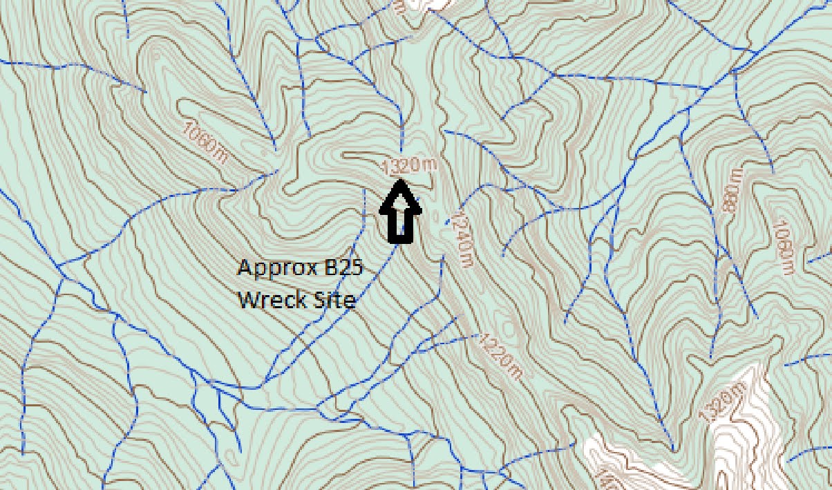
Below: On to the B25 wreck. Firstly here is an updated GE overview of the new predicted position of the B25. It is located north of Youbou on a ridge running northwest of Mt Whymper at about 1300m. You can see Jump Lake in the very top left of the picture.

Below is an overview of the area between Mt Whymper and El Capitan Mountain with the approxomate wreck site located at 49.58.5N 124.11.5W (Degrees Decimal Minutes) For those of you like me who like decimal degrees, look further down...These images are taken from the publicly available maps (online!) from the BC Gvt: this one is map 92/C16 for reference.

Below: GE View of the above map image with the Whymper Ridge clearly visible.

Below: Closer...Whymper Peak is south east of the wreck...
And Below, the same approxomate view in GE

Below: A closeup of the wreck site. There do appear to be some rudimentary trails up and around there. But any sortie will likely be by foot once the bikes can't go any higher...oh for a KTM FreeRider...

Below: A potential trail with Decimal Degrees lat-long grid reference overlay.The Decimal Degree coordinates are, as best as I can convert: 48.975040N -124.191658W

Below: Overview from VIMB of Chemainus River Road which can be taken from north via the Jump Lake end, if you have a key, or, if you don't, from the east, Highway 1, via Copper Canyon Main, which branches into the Chemainus River Road.

Below: a close up of some trails that branch north just after the gate...these take you very close to the wreck's supposed location at the end of the river spur...which appears below...The last bit will be a hike...

More details to follow as they come in...
The crash site is at the 840m level NE of where you have the arrow.
ReplyDeleteThanks for the information, anonymous. I haven't looked any further into this yet, but am planning on it soon. Could you let me know how you know this and if you've seen the wreck. I was leaning away from that area and towards the southside of the actual peak of Whymper (further east) - is that where you mean? I recieved some pictures from a contributer a while ago, and they seem to point to that area. Let me know! You've got me intrigued!
ReplyDeleteCheers and thanks for the comment.
I went to the Blimp crash site a week ago which is a couple of hundred metres from the bomber. AT the time we didn't have the exact details of the bomber (and couldn't see it). I hope to go in soon (we have special permission from the timber co to go in via Jump Lake.)Both the Blimp and Bomber sites are historical war graves even though there were no dead at the blimp crash.
ReplyDeleteLindsay Elms
www.beyondnootka.com
i have been to it and he is right its north east of where u have the arrow
ReplyDeleteThanks, Anonymous. I still haven't got to it yet, but this Summer is the big push for me. I will be focusing on that 840m level NE of my arrow. Cheers!
ReplyDeleteThanks, Anonymous. I still haven't got to it yet, but this Summer is the big push for me. I will be focusing on that 840m level NE of my arrow. Cheers!
ReplyDelete