With the higher temperatures recently, it seems that most of the lower-lying lakes have dried up as far as trout goes. I'm not seeing any rises on my local lake, and, at Bladder lake, neither Andy or I had any significant bites last Sunday. I was pondering this lack of fishing success when I remembered a trip that I took with Ryan a few months ago to Arrowsmith Lake. The lake is the reservoir for Parsville, and, as such is dammed. The banks are open and rocky, so access for fishing is easy. Unfortunately, I have lost the pictures that I took of that trip, so I have snatched some from Google Earth.

Here you can see Arrowsmith Lake from the west looking east towards the dam and the entrance to the lake. The water level obviously fluctuates and this leaves the bank exposed and easy to access for fishing...
Of course, the other major advantage of this lake is it is at 809 metres in elevation (nearly 3000 feet!). This I remember well, as Ryan and I crossed the Englishman River and wound ever higher until we reached the access road, where we had to navigate around a gate post. The access road was exhilarating, and very steep. The bikes went up no problem. At the top, there was the lake, sitting behind the dam.

Again, from far aloft, you can see the exposed banks, and, consequently, how easy this lake would be to fish...
Being so high and deep, this lake is going to remain cool over the summer season and be fishable right through the season...In fact this is the fishing summary report from the website Hook and Bullet
Arrowsmith Lake is a lake located just 6.1 miles from Hilliers, in the province of British Columbia, Canada. Fishermen will find a variety of fish including walleye, rainbow trout and sucker here. Whether you’re spinning, fly fishing or baitcasting your chances of getting a bite here are good.
The route is fairly straight-forward; that is, you proceed as if to Rhododendron, but pass it, and then take the first bridge to your right over the Englishman River. From there it is a question of following the road up to the turnoff to the lake.

This is the path from the 155 main which is about 25 minutes from Doumont or 5 minutes from the North West Bay Logging Division gate in Nanoose

The route profile is staggering...with a maximum grade of 34.4%...Amazing really. The bikes went up and down nicely, although down is very slow in first gear dabbing the brakes.

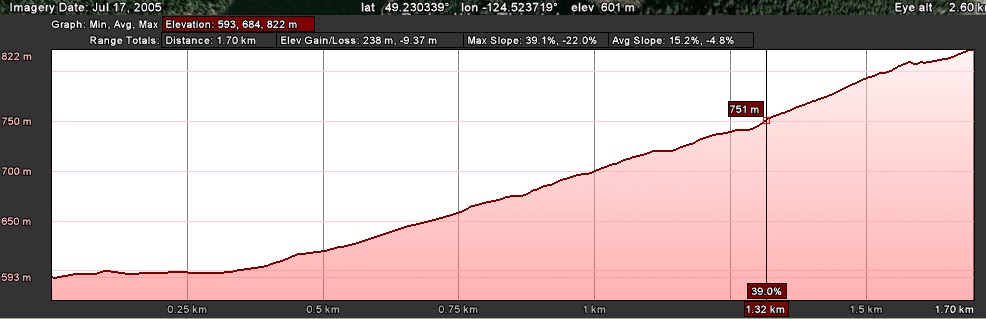
Above is a detail shot of the ride up the Arrowsmith Lake Dam turnoff and up the road. Below is the route profile of just that 1.7km section...with an elevation gain of 229 metres (751 feet over a mile).
So there you go. Worth a cast in my opinion. Perhaps next Sunday if the rain holds off...
Paul
This sounds like a really good ride. The really steep section worries me a bit with my high seat setup, but if you reckon it's manageable I think we should try it. Training wheels maybe???
ReplyDeleteWell I managed once, down was worse, but the bike held no problem. If it looks too hairy, then we leave the bikes halfway up?
ReplyDeletePaul